Change in coordinate CRS in the middle of the file

Hi all,
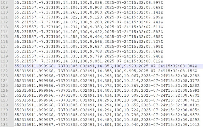
We recently used the BlueBoat with a S500 Cerulean SingleBeam Echosounder to survey a lake in Ireland. When we export the CSV file from SonarView, the coordinates seem to come from an unknown CRS as soon as the survey is started. At the very beginning of the file, the data collected in manual mode while the BlueBoat was manually driven towards its start point are in WGS84. When the vehicle was switched to manual mode in the middle of the survey, these coordinates are still in the other CRS, so it seems that it is really the first start of Auto mode that caused this switch.

Below is a screenshot of the datafile where this change happens. Columns are (from header) : lat (WGS 84), lon (WGS 84), distance (m), confidence (%), elapsed (s), datetime.

My questions :

  • What is this coordinate reference system ? I could not find any match with local Irish systems such as UTMzone, IrishGrid or Irish Transverse Mercator. It is not simply WGS84 x 10**7. Could it be a system local to the BlueBoat?
  • Why is this happening when the coordinates should be given in WGS84?

Thanks for your help,
Coline
**


**
Is it not the same coordinate system, just missing the decimal points?

Hi @ColineMathias -
Welcome to the forums!
This seems like a better question for Cerulean Sonar - you could reach out to their support, or maybe @ljlukis has some feeedback. I’m suspicious of the coordinates after the switch, as they don’t seem to change? Reviewing your SonarView configuration and making sure it is setup to use the vehicle’s GPS via mavlink2rest at 192.168.2.2 can help - sometimes there are issues using blueos.local?

Please Export Configurations in the Sessions Configuration in SonarView and upload this info to the Cerulean support portal and we’ll get it sorted out. Also please upload the svlog file.

Hi Larry,
Thank you, I just submitted the support request.

Hi Tony,
Thanks for your answer. The coordinates do change, I tried at first just to move the comma up 7 decimal places as the coordinates look a lot like WGS84 for the first digits, but when I do so the blueboat track appears coherent in itself, but crammed into a space much smaller than they should occupy on the map, this I why I suspected a local coordinate system.

It is worth noting that the coordinates also have this format in the .BIN BlueBoat logs, so I don’t think this is a problem linked to the S500 but more to the BlueBoat itself.

SonarView configuration is already 192.168.2.2 as we did not receive any coordinates with blueos.local :

"platforms": [
    {
      "id": 1,
      "nickname": "BlueBoat",
      "model": "blue_boat",
      "url": "ws://192.168.2.2:6040/",
      "protocol": "mavlink2rest",
      "options": {
        "system_id": 1,
        "periodic_messages": [
          {
            "message_id": 0,
            "frequency_hz": 1
          },
          {
            "message_id": 30,
            "frequency_hz": 30
          },
          {
            "message_id": 33,
            "frequency_hz": 30
          },
          {
            "message_id": 32,
            "frequency_hz": 30
          },
          {
            "message_id": 137,
            "frequency_hz": 3
          },
          {
            "message_id": 74,
            "frequency_hz": 3
          },
          {
            "message_id": 49,
            "frequency_hz": 0.01
          }
        ]
      }
    }
  ],
  "devices": [
    {
      "id": 1,
      "nickname": "TechWorks Sonar ",
      "product_id": "s500",
      "url": "udp://192.168.2.92:51200",
      "options": {}
    }
  ],
  "default_platform_id": 1,
  "enable_serial_devices": true,
  "log_directory": "/userdata",
  "ntp_server_hostname": "ie.pool.ntp.org"
}

Hi all,

Just an update to help anyone who would have this issue as well. This was linked to a bug in SonarView v1.13.23, and solved in this beta :
https://github.com/CeruleanSonar/SonarView/releases/tag/v1.13.31-beta

1 Like