New Product: The Water Linked Underwater GPS System!

Originally published at: New Product: The Water Linked Underwater GPS System! - Blue Robotics

Today we have a very special new product announcement. We’re partnering with Water Linked, a Norwegian company, and announcing the release of a revolutionarily low-cost Underwater GPS system. This new product, the Water Linked Underwater GPS Explorer Kit combines a traditional GPS receiver and compass with an acoustic positioning system to provide positioning information underwater. We think this technology will be revolutionary to how we use ROVs.

We're partnering with Water Linked as their first and only distributor for this system, and it will also be supported out of the box in ArduSub and the BlueROV2.

The Technology

The Water Linked positioning uses something called Short Baseline (SBL) acoustic positioning. Basically, the ROV has locator beacon that sends out an acoustic pulse. Near the surface, there are four receiver hydrophones lowered into the water. The hydrophones listen for the pulse from the locator beacon and use difference in the time-of-arrival to each receiver to triangulate the ROV's position. SBL systems, compared to the USBL systems more often used on ROVs, have the advantage of working well in shallow water and noisy acoustic environments, such as in a fish cage.

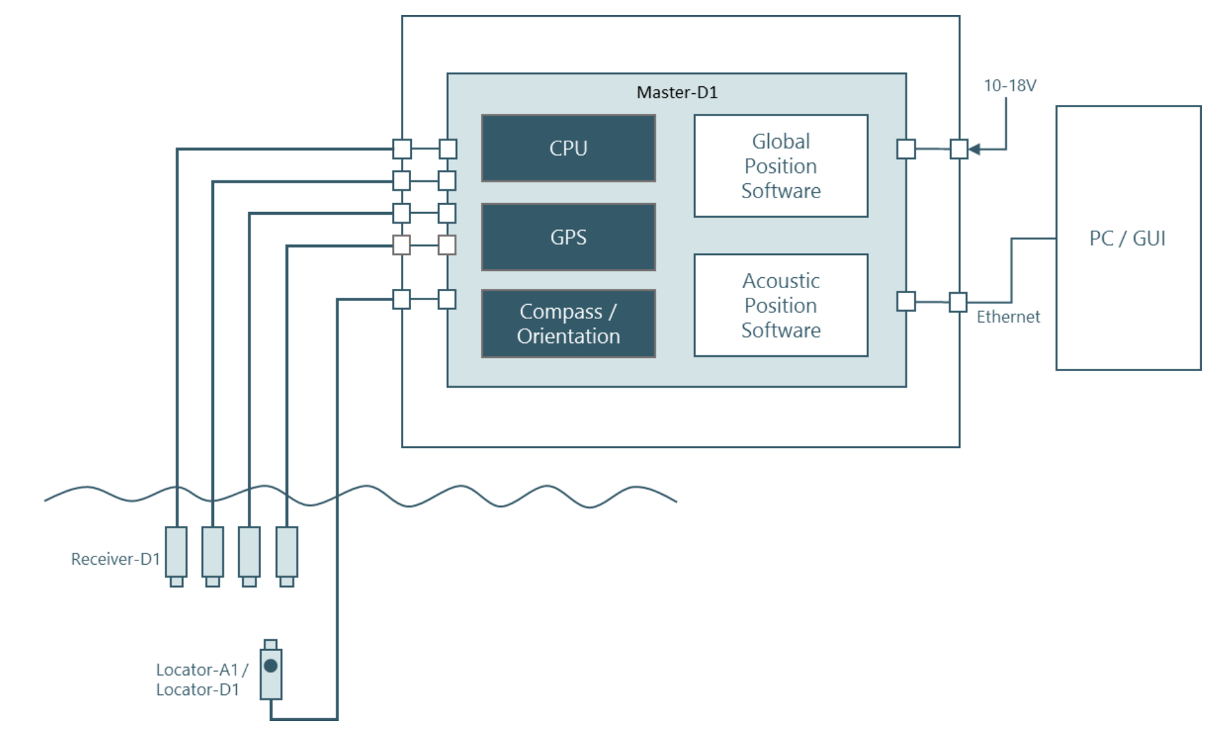
Once the position is known relative to the receivers, the global position can be found by adding that to the position obtained by a GPS receiver. The [Water Linked Underwater GPS system](https://bluerobotics.com/store/sensors-sonars-cameras/underwater-gps/aps-wl-11001/) does that part internally so that it can provide the actual global position of the ROV as it's output.

Why It's Important

The addition of position information when operating an ROV or other marine robotic vehicle is a big change. It means that photos from inspections can be geotagged, targets with known coordinates can be found easily, and ROV can even be programmed to do autonomous actions, such as holding position in a current or following a set of GPS waypoints.

The Water Linked Underwater GPS Explorer Kit

Today were launching the Underwater GPS system in a kit that includes all of the required hardware. The software is in a functional state already, but will be improved quite a bit over the next few months. That includes the addition of a well-documented API, performance improvements, and added features. The system includes everything you need to get started - check out the individual product pages for more details, datasheets, and info.

Orders can be placed today but please note that the first systems won't ship until about June 15th of this year.

The components of this system will also be available separately as spares or for integration directly into your project. We aren't selling these items separately yet, but they'll be available once the product is shipping.

Demo Videos

The guys from Water Linked visited us last month to integrate the Underwater GPS system with the BlueROV2 and show exactly how well it works. We put together three fantastic videos demonstrating the system as we started to test it. These video demonstrate just the early capabilities and performance of the system.

BlueROV2 Position Hold in a Tank with Underwater GPS Positioning:

BlueROV2 Autonomous Navigation with Underwater GPS Positioning:

BlueROV2 Manually Piloted to a Wreck at a Known GPS Coordinate:

We're announcing this in conjunction with the Ocean Business 2017 event in Southampton, UK. If you happen to be there this week, please come visit us at Stand V42!

5 Likes

So uh, what’s the minimum number of the $800 attachments that can be plugged into this thing and still have it find a rov? Does it require all 4 of the relievers to operate?

Hi Tim,

Great question. The underwater GPS system requires four receivers, and one of the more expensive locators to operate. This is what comes standard with the developer kit.

-Jacob

1 Like

Darn, I was afraid of that heh. Ok, guess i’ll have to start saving up for one of these. Anyone know of any ROV equipment grants out there by any chance?

How does this interface with the ROV? Are you using an internal network switch to link the bottomside board and the PI and send both signals up one fathom X tether? or are you adding a second fathom X tether and using 2 additional pairs on the tether with a switch on the topside?

Tim,

No additional electronics are necessary inside the WTE on the BlueROV2. The Locator-A1 is installed on the outside of the ROV with a cable and a penetrator. In that cable are two conductors that are connected directly to one of the spare twisted pairs in the tether. At the top, the Water Linked system can be integrated over the LAN, just like the Raspberry Pi on the ROV.

-Jacob

Hi

Semantics I know but I think Short Baseline (SBL) acoustic positioning system is more accurate description. USBL positioning is standard in my work for positioning something subsea with a range and bearing (especially if it is towed), LBL for more accurate subsea positioning (multiple range and bearings). Each system is able to give you a relative position to say the ship but tying it to the planet requires GPS.

Julian

@julesh - We decided to call the system an “Underwater GPS” because it does have an integrated GPS unit so the resulting position data is global instead of relative. I think it also helps people to understand what it is.

In my experience, people who are relatively new to the subsea world don’t know what a USBL or SBL is and we thought it was important to convey the purpose of the system in its name.

The positioning system of the working frequency, the role of distance and positioning accuracy of the details can reveal some information

From the video point of view, the system is not strong enough to receive the base array, which will continue to maintain the accuracy of the positioning will have a greater impact, and this scale is difficult to arrange on the ship. I think it’s better to call him SBL

Is there any way that the locator could be set up to communicate without a physical tether to the reference receivers? All I really need is an underwater beacon that I can track remotely.

@darguelles - I believe that functionality is in development at Water Linked and will be compatible with this Development Kit once it’s available.

Got a few questions about this new system. What frequency is the transducers centered on and what is the SPL on the output?

I am also curious as to any issues it might have with surface ducting and the ability of the hydrophones to hear the ROV mounted pinger if the ROV happens to be below and acoustic layer. If someone is using this in a lake etc. I doubt this would even be an issue but I was thinking of how it could see operations out in open ocean.

The acoustic technology used in the Underwater GPS uses a wideband transducer. The actual frequencies used depends on the noise/interference at the location. This is automatically adjusted by the Master-D1 module. In general we can say we work in the frequency decade between 50kHz and 500kHz.

The range of the Underwater GPS is 100m, so surface ducting is not really a big issue.

Torgeir
CTO, Water Linked

What type of cross fix accuracy do you get with the system? I haven’t had time to watch any of the video stuff posted on here so if it was contained in there … my bad.

Is there a baseline separation distance requirement between each hydrophone … and is that some parameter that you plug and play into the system to allow it to know? Also, I assume you are not worried about sound velocity since I would assume you know what your timing is with the tether line going to your transducer.

Are you taking into account Sound velocity at all?

The accuracy of the acoustic (relative) positioning depends on a range of factors. But as a rule of thumb we say the accuracy is about 1% of the distance to the receivers. The receivers should be separated with a few meters to get a good resolution on longer ranges. When calculating the global position, GPS and compass also contributes to the uncertainty. Compass deviation caused by local magnetic disturbance can shift the global position significantly.

That said, the system is by far the most robust acoustic positioning system of my knowledge in challenging environments with reflections, absorption and background noise. You guys should test it!

Torgeir Trøite
CTO, Water Linked

Sound velocity is one of several factors that is used when estimating the position.

1 Like

Since you say, I am assuming, that sound velocity is a factor … are you measuring velocity based upon ping time and ping reception time? The profilers we used on submarines pretty much did that but the transducers were really close to each other.

As much as would love to, I can’t go into details on how we technically have solved the problem of estimating position in shallow water environment :wink:

1 Like